
Sale!

Green Trails Map 4093SX – Wasatch Back, UT
Original price was: $18.00.$12.24Current price is: $12.24.
- Experience the Best Quality
- 7 Days of Hassle-Free Returns
- Protecting Your Payment Information
- High quality products, low prices.

Stretching from to Wanship to Sundance, the Green Trails Wasatch Back map (4093SX) offers a beautifully detailed topographic guide to this region in Utah.
Features
- Covers Wasatch Mountain State Park, Jordanell, Provo River, Deer Creek, West Hills, Park City and Deer Valley National Forest
- Green Trails Maps show current trail, road and access information to national forests, national parks, state and local parks, and other public lands
- Printed on waterproof and tear-resistant paper with a 60% larger format, this map withstands the rigors of adventures in less than ideal conditions
Made in USA.
Technical Specs
| Best Use | Hiking |
|---|---|
| State / Province | Utah |
| Folded Dimensions | 6 x 9 inches |
| Unfolded Dimensions | 30 x 22.5 inches |
| Map Scale | 1:35,250 |
| Double Sided | Yes |
| Waterproof | Yes |
| Publisher | Green Trails Maps |
| Copyright Year | 2020 |
| Color | None |
|---|
Be the first to review “Green Trails Map 4093SX – Wasatch Back, UT”
Related products
Sale!

Books and Maps
Original price was: $19.95.$12.17Current price is: $12.17.
Sale!
Books and Maps
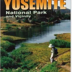
Wilderness Press 50 Best Short Hikes in Yosemite National Park and Vicinity – 2nd Edition
Original price was: $16.95.$10.51Current price is: $10.51.
Sale!

Original price was: $24.95.$16.22Current price is: $16.22.
Sale!
Original price was: $24.95.$15.72Current price is: $15.72.
Sale!

Books and Maps
Original price was: $16.95.$11.02Current price is: $11.02.
Sale!
Original price was: $19.95.$14.76Current price is: $14.76.
Sale!

Original price was: $24.95.$14.97Current price is: $14.97.
Sale!

Books and Maps
Original price was: $21.95.$16.24Current price is: $16.24.
Reviews
There are no reviews yet.