
Sale!

Green Trails Map 2962S – Santa Rita Mountains
Original price was: $14.00.$9.38Current price is: $9.38.
- Experience the Best Quality
- 7 Days of Hassle-Free Returns
- Protecting Your Payment Information
- High quality products, low prices.

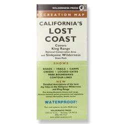
Centered around Mt. Wrightson, the Green Trails Santa Rita Mountains map (2962S) offers a beautifully detailed topographic guide to this region of southern Arizona.
Features
- Covers Mt. Wrightson and Whipple Observatory Visitor Center; includes a 1:26,000 Madera Canyon inset
- Green Trails Maps show current trail, road and access information to national forests, national parks, state and local parks, and other public lands
- Printed on a waterproof and tear-resistant sheet
Made in USA.
Technical Specs
| Best Use | Hiking |
|---|---|
| State / Province | Arizona |
| Folded Dimensions | Unavailable |
| Unfolded Dimensions | Unavailable |
| Waterproof | Yes |
| Publisher | Mountaineers Books |
| Copyright Year | 2014 |
| Color | None |
|---|
Be the first to review “Green Trails Map 2962S – Santa Rita Mountains”
Related products
Sale!

Books and Maps
Original price was: $24.95.$15.47Current price is: $15.47.
Sale!

Original price was: $15.95.$9.57Current price is: $9.57.
Sale!

Original price was: $19.95.$13.37Current price is: $13.37.
Sale!
Original price was: $24.95.$15.72Current price is: $15.72.
Sale!

Books and Maps
Original price was: $21.95.$16.24Current price is: $16.24.
Sale!

Original price was: $24.95.$16.22Current price is: $16.22.
Sale!

Books and Maps
Original price was: $19.95.$13.77Current price is: $13.77.
Sale!
Books and Maps
Original price was: $12.95.$8.81Current price is: $8.81.
Reviews
There are no reviews yet.