
Sale!


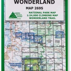

Green Trails Map 269S – Mount Rainier Wonderland
Original price was: $18.00.$10.98Current price is: $10.98.
- Experience the Best Quality
- 7 Days of Hassle-Free Returns
- Protecting Your Payment Information
- High quality products, low prices.

The Green Trails Mount Rainier Wonderland map offers a beautifully detailed topographic guide to Mount Rainier National Park and the famous Wonderland Trail.
Features
- Printed on waterproof and tear-resistant paper, this map stands up to the rigors of your outdoor adventure
- One side features the entire national park at a scale of 1:63,360; the other side shows a 1:24,000 climbing map with the most popular routes to the summit
- Map includes a Wonderland Trail elevation profile, GPS waypoints and climbing route details
Made in USA.
Technical Specs
| Best Use | Hiking |
|---|---|
| State / Province | Washington |
| Unfolded Dimensions | 30 x 22.5 inches |
| Map Scale | 1:63,360 (main map); back: 1:24,000 (climbing routes) |
| Double Sided | Yes |
| Waterproof | Yes |
| Publisher | Green Trails Maps |
| Copyright Year | 2010 |
| Map Number | 269S 269S |
| Color | None |
|---|
Be the first to review “Green Trails Map 269S – Mount Rainier Wonderland”
Related products
Sale!
Original price was: $24.95.$16.22Current price is: $16.22.
Sale!

Books and Maps
Original price was: $19.95.$12.17Current price is: $12.17.
Sale!
Books and Maps
Original price was: $12.95.$8.81Current price is: $8.81.
Sale!
Original price was: $24.95.$14.97Current price is: $14.97.
Sale!
Books and Maps
Original price was: $21.95.$16.24Current price is: $16.24.
Sale!
Books and Maps
Wilderness Press Best Summit Hikes in Colorado – 2nd Edition
Original price was: $18.95.$11.94Current price is: $11.94.
Sale!

Books and Maps
Original price was: $19.95.$13.57Current price is: $13.57.
Sale!

Books and Maps
Original price was: $19.95.$13.77Current price is: $13.77.
Reviews
There are no reviews yet.